വിക്കിപീഡിയ, ഒരു സ്വതന്ത്ര വിജ്ഞാനകോശം.
ഒഹായോ നദി
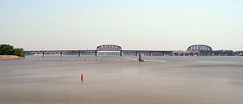
The widest point on the Ohio River is just west of
downtown Louisville , where it is one mile (1.6 km) wide
രാജ്യം
United States
സംസ്ഥാനങ്ങൾ
Pennsylvania ,Ohio ,West Virginia ,Kentucky ,Indiana ,Illinois
പോഷക നദികൾ
- ഇടത്
Little Kanawha River ,Kanawha River ,Guyandotte River ,Big Sandy River ,Little Sandy River ,Licking River ,Kentucky River ,Salt River ,Green River ,Cumberland River ,Tennessee River
- വലത്
Beaver River ,Little Muskingum River ,Muskingum River ,Little Hocking River ,Hocking River ,Shade River ,Scioto River ,Little Miami River ,Great Miami River ,Wabash River
പട്ടണങ്ങൾ
Pittsburgh, PA ,Wheeling, WV ,Huntington, WV ,Parkersburg, WV ,Cincinnati, OH ,Louisville, KY ,Owensboro, KY ,Evansville, IN ,Henderson, KY ,Paducah, KY ,Cairo, IL , East Liverpool, OH
സ്രോതസ്സ്
Allegheny River
- സ്ഥാനം
Allegany Township , Potter County Pennsylvania
- ഉയരം
2,240 അടി (683 മീ)
- നിർദേശാങ്കം
41°52′22″N 77°52′30″W / 41.87278°N 77.87500°W / 41.87278; -77.87500
ദ്വിതീയ സ്രോതസ്സ്
Monongahela River
- location
Fairmont , West Virginia
- ഉയരം
880 അടി (268 മീ)
- നിർദേശാങ്കം
39°27′53″N 80°09′13″W / 39.46472°N 80.15361°W / 39.46472; -80.15361
Source confluence
- സ്ഥാനം
Pittsburgh , Pennsylvania
- ഉയരം
730 അടി (223 മീ)
- നിർദേശാങ്കം
40°26′32″N 80°00′52″W / 40.44222°N 80.01444°W / 40.44222; -80.01444
അഴിമുഖം
Mississippi River
- സ്ഥാനം
at Cairo, Illinois / Ballard County, Kentucky
- ഉയരം
290 അടി (88 മീ)
- നിർദേശാങ്കം
36°59′12″N 89°07′50″W / 36.98667°N 89.13056°W / 36.98667; -89.13056
നീളം
981 മൈ (1,579 കി.മീ)
നദീതടം
189,422 ച മൈ (490,601 കി.m2 )
Discharge
for Cairo, Illinois
- ശരാശരി
281,000 cu ft/s (7,957 m3 /s) (1951–80)[ 1]
- max
1,850,000 cu ft/s (52,386 m3 /s)
Ohio River basin
ഒഴുകുന്ന വെള്ളത്തിന്റെ അനുപാതത്തിൽ മിസിസിപ്പി നദിയുടെ വലിയ കൈവഴിയാണ് പെൻസിൽവാനിയയിലെ പിറ്റ്സ്ബർഗ് മുതൽ ഇല്ലിനോയിയിലെ കയ്റൊ വരെ ഒഴുകുന്ന ഒഹായോ നദി
981-മൈൽ (1,579 കി.മീ) നീളമുള്ള ഈ നദി ആറു സംസ്ഥാനങ്ങളിലൂടെ/സംസ്ഥാനാതിർത്തികളിലൂടെയായി ഒഴുകുന്നു[ 2]
പിറ്റ്സ്ബർഗിലെ പോയിന്റ് സ്റ്റേറ്റ് പാർക്കിൽ അലിഗെനി , മോണൊഗല എന്നീ നദികൾ സംഗമിച്ചാണ് ഒഹയോ നദിയാവുന്നത്.ആദ്യം വടക്കുപടിഞ്ഞാറായും പിന്നീട് പെട്ടെന്ന് ദിശ മാറി തെക്ക്-തെക്ക്പടിഞ്ഞാറയും ഒഴുകുന്നു.


