അയർലന്റ്
ദൃശ്യരൂപം
| |
|---|---|
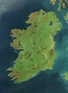
 Satellite image, October 2010 | |
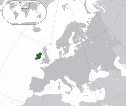
 Location of Ireland (dark green) on the European continent (dark grey) | |
| Geography | |
| Location | Northwestern Europe |
| Coordinates | 53°25′N 8°0′W / 53.417°N 8.000°W |
| Adjacent bodies of water | Atlantic Ocean |
| Area | 84,421 കി.m2 (32,595 ച മൈ)[1] |
| Area rank | 20th[2] |
| Coastline | 7,527 km (4,677.1 mi)[3][4] |
| Highest elevation | 1,041 m (3,415 ft) |
| Highest point | Carrauntoohil |
| Administration | |
| Largest city | Dublin (pop. 1,173,179) |
| Country | Northern Ireland |
| Largest city | Belfast (pop. 343,542) |
| Demographics | |
| Demonym | Irish |
| Population | 7,026,636 (2022)[a][7] |
| Population rank | 19th |
| Pop. density | 77.8 /km2 (201.5 /sq mi) |
| Languages | |
| Ethnic groups | |
| Additional information | |
| Time zone | |
| • Summer (DST) | |
| Patron saints | Saint Patrick Saint Brigid Saint Colmcille |
| |
പശ്ചിമ യൂറോപ്പിൽ വടക്കൻ അറ്റ്ലാന്റിക് സമുദ്രത്തിൽ 84,421 ച.കി.മീ. വിസ്തൃതിയിൽ കിടക്കുന്ന ദ്വീപാണ് അയർലന്റ്. നോർത്ത് ചാനൽ, ഐറിഷ് കടൽ, സെന്റ് ജോർജ്ജ് ചാനൽ, കെൽട്ടിക് കടൽ എന്നിവ വടക്കു മുതൽ തെക്കു വരെ (ഘടികാരദിശയിൽ) അതിരിടുന്നു. അയർലന്റിനു കിഴക്കായാണ് പ്രധാന ബ്രിട്ടീഷ് ദ്വീപായ ഗ്രേറ്റ് ബ്രിട്ടൻ സ്ഥിതി ചെയ്യുന്നത്. അയർലന്റ് ദ്വീപ് എയ്റ എന്നാണ് ഐറിഷ് ഭാഷയിൽ അറിയപ്പെടുന്നത്. ഹരിതാഭമായ ഭൂപ്രകൃതി കാരണം മരതകദ്വീപ് എന്നൊരു ചെല്ലപ്പേരുണ്ട്.
അയർലന്റ് ദ്വീപിലെ ആറിൽ അഞ്ച് ഭാഗത്തോളം വരുന്ന തെക്കൻ മേഖലയാണ് റിപ്പബ്ലിക്ക് ഓഫ് അയർലണ്ട് എന്ന രാജ്യം. അവശേഷിച്ച വടക്കൻ മേഖല ഉത്തര അയർലന്റ് എന്ന പേരിൽ ബ്രിട്ടന്റെ ഭാഗമാണ്.
അവലംബം
[തിരുത്തുക]- ↑ Nolan, William. "Geography of Ireland". Government of Ireland. Archived from the original on 24 നവംബർ 2009. Retrieved 11 നവംബർ 2009.
- ↑ Royle, Stephen A. (1 ഡിസംബർ 2012). "Beyond the boundaries in the island of Ireland". Journal of Marine and Island Cultures. 1 (2): 91–98. doi:10.1016/j.imic.2012.11.005.
- ↑ "Irish Coastal Habitats: A Study of Impacts on Designated Conservation Areas" (PDF). heritagecouncil.ie. Heritage Council. Archived (PDF) from the original on 3 ഡിസംബർ 2020. Retrieved 2 നവംബർ 2020.
- ↑ Neilson, Brigitte; Costello, Mark J. (22 ഏപ്രിൽ 1999). "The Relative Lengths of Seashore Substrata Around the Coastline of Ireland as Determined by Digital Methods in a Geographical Information System". Estuarine, Coastal and Shelf Science. 49 (4). Environmental Sciences Unit, Trinity College, Dublin: 501–508. Bibcode:1999ECSS...49..501N. doi:10.1006/ecss.1999.0507. S2CID 128982465. Archived from the original on 13 ജൂലൈ 2021. Retrieved 13 ജൂലൈ 2021.
- ↑ "This is Ireland: Highlights from Census 2011 Part 1". Central Statistics Office. മാർച്ച് 2012. p. 94. Archived from the original on 31 മാർച്ച് 2012. Retrieved 28 മേയ് 2014.
- ↑ "Census 2011, Key Statistics for Northern Ireland" (PDF). Department of Finance and Personnel's Northern Ireland Statistics and Research Agency. ഡിസംബർ 2012. p. 13. Archived from the original (PDF) on 24 ഡിസംബർ 2012. Retrieved 2 ഫെബ്രുവരി 2014.
- ↑ ഉദ്ധരിച്ചതിൽ പിഴവ്: അസാധുവായ
<ref>ടാഗ്;2022populationഎന്ന പേരിലെ അവലംബങ്ങൾക്ക് എഴുത്തൊന്നും നൽകിയിട്ടില്ല.
വർഗ്ഗങ്ങൾ:
- Pages using gadget WikiMiniAtlas
- Pages using the JsonConfig extension
- Articles with hatnote templates targeting a nonexistent page
- Use dmy dates from March 2013
- Articles containing Irish-language text
- Articles containing Scots-language text
- Articles using infobox islands with additional info
- അയർലന്റ്
- പടിഞ്ഞാറൻ യൂറോപ്പ്
