ക്യാറ്റ്സ്കിൽ പാർക്ക്
ദൃശ്യരൂപം
| ക്യാറ്റ്സ്കിൽ പാർക്ക് | |
| New York Forest Preserve | |
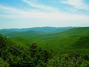
View to central Catskills from Twin Mountain
| |
| രാജ്യം | അമേരിക്ക |
|---|---|
| സംസ്ഥാനം | ന്യൂ യോർക്ക് |
| Region | Catskill Mountains |
| Counties | Delaware, Greene, Sullivan, Ulster |
| River | Esopus Creek, Neversink River, Rondout Creek, Schoharie Creek |
| Coordinates | 42°05′N 74°30′W / 42.083°N 74.500°W |
| Highest point | Slide Mountain |
| - location | Shandaken |
| - ഉയരം | 4,180 അടി (1,274 മീ) |
| Lowest point | Saw Kill along Blue Line N |
| - location | W of Kingston |
| - ഉയരം | 120 അടി (37 മീ) |
| Area | 1,120 ച മൈ (2,901 കി.m2) |
| Geology | Sedimentary Devonian shale and sandstone |
| Founded | 1885 |
| Owner | New York State Department of Environmental Conservation, local governments, private landowners |
| For public | Yes |
| Visitation | 553,000 (2002) |
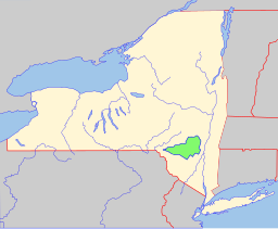
Catskill Park within New York state
| |
Location of New York in the United States
| |
അമേരിക്കൻ ഐക്യനാടുകളിലെ ന്യൂയോർക്ക് പട്ടണത്തിൽ നിന്നും 220 കിലോമീറ്റർ അകലെയായി ക്യാറ്റ്സ്കിൽ മൗണ്ടനിൽ സ്ഥിതി ചെയ്യുന്ന ഒരു സംരക്ഷിതവനമേഖലയാണ് ക്യാറ്റ്സ്കിൽ പാർക്ക്. ഇതിൽ വന്യജീവി സങ്കേതം, സംരക്ഷിത വനം, അഞ്ച് നദികൾ, പത്ത് പർവ്വതങ്ങൾ, ചെറിയ അരുവികൾ എന്നിവ ഉൾക്കൊള്ളുന്നു. ഇവിടെ നിന്നുമാണ് ന്യൂ യോർക്ക് നഗരത്തിനാവശ്യമായ ജലം ലഭ്യമാക്കുന്നത്[1]. 700,000 ഏക്കറാണ് പാർക്കിന്റെ വിസ്തൃതി.
ന്യൂ യോർക്കിലെ സ്ലൈഡ് മൗണ്ടൻ (Slide Mountain) എന്ന പർവ്വതം ക്യാറ്റ്സ്കിൽ പാർക്കിലാണ് സ്ഥിതി ചെയ്യുന്നത്. ന്യൂ യോർക്കിലെ ഏറ്റവും വലിയ രണ്ടാമത്തെ പർവ്വതമാണിത്. ഇത് സമുദ്ര നിരപ്പിൽ നിന്നും 4200 അടി ഉയരത്തിൽ നിലകൊള്ളുന്നു.

അവലംബം
[തിരുത്തുക]- ↑ "ആർക്കൈവ് പകർപ്പ്". Archived from the original on 2011-07-28. Retrieved 2011-03-02.
പുറത്തേക്കുള്ള കണ്ണികൾ
[തിരുത്തുക]- [1] Archived 2011-07-28 at the Wayback Machine Catskill Water Discovery Center
- Hiking Guide to the Catskill High Peaks Archived 2011-02-27 at the Wayback Machine Catskill 3500 Club
- The Catskill Center for Conservation and Development
- Catskill Forest Preserve Archived 2018-11-10 at the Wayback Machine
- NY-NJTC: Catskill Park Trail Details and Info


