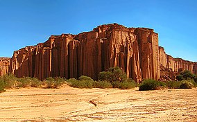
തലമ്പായ ദേശീയോദ്യാനം
ദൃശ്യരൂപം
| Talampaya National Park | |
|---|---|
ഐ.യു.സി.എൻ. ഗണം II (ദേശീയോദ്യാനം) | |
 Wall at the channel system | |
| Location | La Rioja Province, Argentina |
| Nearest city | Villa Unión |
| Coordinates | പ്രയോഗരീതിയിൽ പിഴവ്: തിരിച്ചറിയാൻ കഴിയാത്ത വിരാമചിഹ്നം ","km 29°48′S 67°50′W / 29.800°S 67.833°W |
| Area | 2,150 കി.m2 (830 ച മൈ) |
| Established | 1997 |
| Governing body | Administración de Parques Nacionales |
| Official name | Ischigualasto and Talampaya Natural Parks |
| Type | Natural |
| Criteria | viii |
| Designated | 2000 (24th session) |
| Reference no. | 966 |
| State Party | Argentina |
| Region | Latin America and the Caribbean |
താലമ്പായ ദേശീയോദ്യാനം, അർജന്റീനയിലെ ലാ റിയോജ പ്രവിശ്യയുടെ കിഴക്കു/മദ്ധ്യ ഭാഗത്തായുള്ള ദേശീയോദ്യാനമാണ്. 1975 ൽ ഒരു പ്രാദേശിക ഉദ്യാനമായും, 1997 ൽ ഒരു ദേശീയോദ്യാനമായും, 2000 ൽ ഒരു യുനെസ്കോ ലോക പൈതൃക സ്ഥലമായും നാമനിർദ്ദേശം ചെയ്യപ്പെട്ടു.
സ്ഥാനം
[തിരുത്തുക]അർജന്റൈൻ മൊണ്ടേ ആവാസ വ്യവസ്ഥയിലുള്ള ഒരു പ്രദേശത്തെ ഈ ദേശീയോദ്യാനം സംരക്ഷിക്കുന്നു.[1] 2,150 സ്ക്വയർ കിലോമീറ്റർ (830 സ്ക്വയർ മൈൽ) വിസ്തൃതിയിൽ, സമുദ്രനിരപ്പിൽനിന്ന് ശരാശരി 1,500 മീറ്റർ (4,921 അടി), ഉയരത്തിൽ വ്യാപിച്ചു കിടക്കുന്നതാണ് ഈ പാർക്ക്.
ചിത്രശാല
[തിരുത്തുക]-
Parque Nacional de Talampaya
-
Talampaya canyon entrance
-
Petroglyphs
-
Parque Nacional Talampaya
-
Tour buses at the park
-
Rhea
-
The wall
അവലംബം
[തിരുത്തുക]- ↑ Dellafiore, Claudia, Southern South America: Southern Argentina, stretching northward (NT0802), WWF: World Wildlife Fund, retrieved 2017-04-12


