പുതുമായോ നദി
ദൃശ്യരൂപം
| പുതുമായോ നദി | |
|---|---|
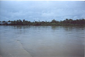
 Putumayo at Puerto Asis, Colombia | |
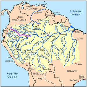
 Map of the Amazon Basin with the Putumayo River highlighted in pink | |
| മറ്റ് പേര് (കൾ) | Río Içá |
| Country | Brazil, Colombia, Ecuador, Peru |
| Physical characteristics | |
| പ്രധാന സ്രോതസ്സ് | Andes Mountains East of Pasto, Colombia 6,000 മീ (20,000 അടി) |
| നദീമുഖം | Amazon River Santo Antônio do Içá, Brazil 3°8′6″S 67°58′27″W / 3.13500°S 67.97417°W |
| നീളം | 1,610 കി.മീ (1,000 മൈ)[1] |
| Discharge |
|
| നദീതട പ്രത്യേകതകൾ | |
| പോഷകനദികൾ |
|
ആമസോൺ നദിയുടെ ഒരു പോഷകനദിയാണ് ഇകാ നദി അഥവാ പുതുമായോ നദി (Spanish: Río Putumayo, Portuguese: Río Içá). ഇത് ജാപുര നദിയുടെ പടിഞ്ഞാറായിട്ട് ആ നദിക്ക് സമാന്തരമായിട്ടാണ് ഒഴുകുന്നത്.[2][3]ഈ നദി കൊളംബിയയുമായും ഇക്വഡോറുമായും പെറുവുമായും അതിർത്തി പങ്കിടുന്നു. ഈ മൂന്ന് രാജ്യങ്ങളിലും പുതുമായോ എന്ന പേരിൽ അറിയപ്പെടുന്ന ഈ നദി ബ്രസീലിലേക്ക് കടക്കുമ്പോൾ ഇകാ എന്നറിയപ്പെടുന്നു.
അവലംബം
[തിരുത്തുക]- ↑ Ziesler, R.; Ardizzone, G.D. (1979). "Amazon River System". The Inland waters of Latin America. Food and Agriculture Organization of the United Nations. ISBN 92-5-000780-9. Archived from the original on 8 November 2014.
- ↑ Ziesler, R.,. Las aguas continentales de América Latina = The inland waters of Latin America. Ardizzone, G. D.,. Roma. ISBN 9250007809. OCLC 8345064.
{{cite book}}: CS1 maint: extra punctuation (link) CS1 maint: multiple names: authors list (link) - ↑ Hernández-Gutiérrez, Antonio; Chaves, Zuleide Martins; Dornelo-Silva, Denise; Dianese, José Carmine (2015-12-18). "Additions to the cercosporoid fungi from the Brazilian Cerrado: 1. New species on hosts belonging in family Fabaceae, and reallocations of four Stenella species into Zasmidium". MYCOBIOTA. 5: 33–64. doi:10.12664/mycobiota.2015.05.06. ISSN 1314-7129.
പുറം കണ്ണികൾ
[തിരുത്തുക] . കോളിയേഴ്സ് ന്യൂ എൻസൈക്ലോപീഡിയ. 1921.
 {{cite encyclopedia}}: Cite has empty unknown parameter:|HIDE_PARAMETER=(help)- Hardenburg, W.E. 1913. The Putumayo: The Devil's Paradise—Travels in the Peruvian Amazon Region and An Account of The Atrocities Committed Upon the Indians Therein. London: T. Fisher Unwin. https://archive.org/details/putumayodevilspa00hardrich
