ഫലകം:Infobox Military Structure/വിവരണം
| ഇത് ഫലകം:Infobox Military Structure എന്ന ഫലകത്തിന്റെ വിവരണ-ഉപതാൾ ആണ് (ഫലകത്തിനായി ആ താൾ കാണുക). ഇതിൽ യഥാർത്ഥ ഫലകം ഉപയോഗിക്കേണ്ട രീതി, വർഗ്ഗങ്ങൾ, ബഹുഭാഷാകണ്ണികൾ തുടങ്ങിയ ഫലകത്തിന്റെ ഭാഗമല്ലാത്ത കാര്യങ്ങളാണ് ഉള്ളത്.. |
Usage
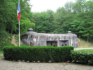
| Maginot Line | |
|---|---|
| Eastern France | |

| |
| The entrance to Ouvrage Schoenenbourg along the Maginot Line in Alsace. | |
| തരം | Defensive line |
| Site information | |
| Controlled by | France |
| Site history | |
| Built | 1930–35 |
| In use | 1935–69 |
| Materials | Concrete, steel |
| Battles/wars | Battle of France |
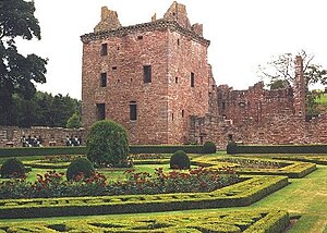
| Edzell Castle | |
|---|---|
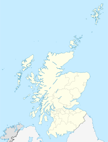
| Near Edzell, Angus, Scotland grid reference NO584691 | |

| |
| Edzell Castle and gardens | |
| തരം | Tower house and courtyard |
| Site information | |
| Owner | Earl of Dalhousie, managed by Historic Scotland |
| Controlled by | Lindsays of Edzell |
| Open to the public |
Yes |
| Condition | Ruined |
| Site history | |
| Built | c.1520-1610 |
| In use | Until 1715 |
| നിർമ്മിച്ചത് | David Lindsay, 9th Earl of Crawford |
| Materials | Old Red Sandstone |
A military structure infobox may be used to summarize information about a military structure or facility, such as a fortification or military base.
The infobox should be added using the {{Infobox Military Structure}} template, as shown below:
{{Infobox Military Structure
|name =
|partof =
|location =
|image =
|caption =
|map_type =
|latitude =
|longitude =
|map_size =
|map_caption =
|type =
|coordinates =
|code =
|built = {{Start date|YYYY}}
|builder =
|materials =
|height =
|used =
|demolished =
|condition =
|ownership =
|open_to_public =
|controlledby =
|garrison =
|current_commander =
|commanders =
|occupants =
|battles =
|events =
|image2 =
|caption2 =
}}
Note: When using parameters, avoid the ambiguous abbreviation "N/A", and instead use "unknown" or "none". All subjective or qualitative judgements and numerical quantities or statistics must be cited to a reliable source (see WP:MILMOS#CITE).
- name – the name of the structure or facility.
- partof – optional – the larger structure or complex the given structure is part of, if any. For proper grammar, it may be necessary to insert "the" before the name used here.
- location – the geographical location of the structure.
- image – optional – an image of the structure. The image must be given in the form [[Image:Example.jpg|300px]]; in particular, the thumb attribute must not be selected.
- caption – optional – the text to be placed below the image.
- map_type – optional – the base map to be used for the location map, e.g. "Scotland"; see {{location map}} for more details.
- latitude – optional – latitude for placing the marker on the location map, e.g. "56.81".
- longitude – optional – longitude for placing the marker on the location map, e.g. "-2.68".
- map_size – optional – width of the location map in pixels (px), e.g. "150"; defaults to: "220".
- map_caption – optional – caption displayed below the location map; defaults to "Shown within {{{map_type}}}", e.g. "Shown within Scotland".
- type – optional – the general type of structure ("Castle", "Fortress", "Bunker", "Military base", "Wall", "Defensive line", etc.).
- coordinates – optional – the location of the structure, given as a coordinate pair by using {{coord}} with display=inline,title.
- code – optional – the location or facility code, such as the ILC or ILK code.
- built – optional – the date when the structure was built (usually given in years). Use {{Start date}} if after 1583.
- builder – optional – the person or group responsible for building the structure.
- materials – optional – the materials used to construct the structure.
- height – optional – where relevant (e.g. for towers), the height of the structure.
- used – optional – the period during which the structure was in active military use, usually given in years.
- demolished – optional – the date when the structure was demolished, if applicable.
- condition – optional – the current condition of the structure.
- ownership – optional – the current owner of the structure, if relevant.
- open_to_public – optional – whether the structure is currently open to the general public, if relevant; indicated by "yes" or "no".
- controlledby – optional – the country or other power controlling the structure. Multiple powers may be indicated together with the corresponding dates.
- garrison – optional – the military forces garrisoning the structure. Specific units may be indicated if known; general numbers should be given otherwise.
- current_commander – optional – for structures currently in military use, the current commanding officer.
- commanders – optional – any notable individuals that commanded the forces using this structure; the choice of which commanders qualify as notable is left to the editors of a particular article.
- occupants – optional – any notable occupants of the structure other than its commanders; as above, the choice of which occupants qualify as notable is left to the editors of a particular article.
- battles – optional – any notable battles (usually sieges) that took place in or are closely associated with the structure; as above, the choice of which battles qualify as notable is left to the article editors.
- events – optional – any notable non-battle events that took place in or are closely associated with the structure. As above, the choice of which events are notable is left to the article editors.
- image2 – optional – a second image of the structure. The image must be given in the form [[Image:Example.jpg|300px]]; in particular, the thumb attribute must not be selected.
- caption2 – optional – the text to be placed below the second image.
Microformat
The HTML markup produced by this template includes an hCard microformat, which makes the place-name and location parsable by computers, either acting automatically to catalogue articles across Wikipedia, or via a browser tool operated by a person, to (for example) add the subject to an address book. Within the hCard is a Geo microformat, which additionally makes the coordinates (latitude & longitude) parsable, so that they can be, say, looked up on a map, or downloaded to a GPS unit. For more information about the use of microformats on Wikipedia, please see the microformat project.
Sub-templates
[തിരുത്തുക]If the place or venue has "established", "founded", "opened" or similar dates, use {{start date}} for the earliest of those dates unless the date is before 1583 CE.
If it has a URL, use {{URL}}.
Please do not remove instances of these sub-templates.
Classes
[തിരുത്തുക]hCard uses HTML classes including:
- adr
- agent
- category
- county-name
- extended-address
- fn
- label
- locality
- nickname
- note
- org
- region
- street-address
- uid
- url
- vcard
Geo is produced by calling {{coord}}, and uses HTML classes:
- geo
- latitude
- longitude
Please do not rename or remove these classes nor collapse nested elements which use them.
Precision
[തിരുത്തുക]When giving coordinates, please use an appropriate level of precision. Do not use {{coord}}'s |name= parameter.

