ബ്യൂണസ് ഐറീസ്
ദൃശ്യരൂപം
Ciudad Autónoma de Buenos Aires | |||
|---|---|---|---|
| Ciudad Autónoma de Buenos Aires സ്വയംഭരണ നഗരമായ ബ്യൂണസ് ഐറിസ് | |||
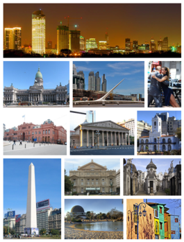
 മുകളിൽനിന്ന് ഘടികാരദിശയിൽ: വൈകുന്നേരം നഗരത്തിന്റെ സ്കൈലൈൻ, നാഷണൽ കോൺഗ്രസ്, പുവെർട്ടോ മദേറോയിലെ സ്ത്രീകളുടെ ബ്രിഡ്ജ്, സാൻ തെൽമോയിലെ റ്റാങ്ഗോ നർത്തകർ, ദി പിങ്ക് ഹൗസ്,മെട്രൊപ്പൊളിറ്റൻ കത്തീഡ്രൽ, കബിൽഡോ, സ്തൂപം, കോളൺ തിയേറ്റർ, ല റക്കോളെറ്റ ശവകുടീരം, പാലെർമോ വുഡ്സിലെ പ്ലാനെറ്റേറിയം, ല ബോക്കയിലെ കമിനിത്തോ. | |||
| |||
| Nickname(s): റയോ ദെ ല പ്ലാറ്റ (പ്ലേറ്റ് നദിയുടെ റാണി), തെക്കേ അമേരിക്കൻ പാരിസ്, റ്റാങ്ഗോ തലസ്ഥാനം, പുസ്തകങ്ങളുടെ നഗരം, പാമ്പാസിന്റെ പാരിസ്,[1] ലാറ്റിൻ അമേരിക്കയുടെ സാംസ്കാരിക തലസ്ഥാനം[2] | |||
| Coordinates: 34°36′12″S 58°22′54″W / 34.60333°S 58.38167°W | |||
| രാജ്യം | അർജന്റീന | ||
| സ്ഥാപിതം | 1536, 1580 | ||
| • സർക്കാരിന്റെ മേധാവി | മൗറീഷ്യോ മസ്രി | ||
| • സെനറ്റർമാർ | മരിയ യൂജീനിയ എസ്റ്റെൻസ്സോറൊ, സാമുവൽ കബാൻചിക്ക്, ഡാനിയേൽ ഫിൽമൂസ് | ||
| • സ്വയംഭരണ നഗരം | 203 ച.കി.മീ.(78.5 ച മൈ) | ||
| • ഭൂമി | 203 ച.കി.മീ.(78.5 ച മൈ) | ||
| • മെട്രോ | 4,758 ച.കി.മീ.(1,837 ച മൈ) | ||
(2010 കാനേഷുമാരി.)[3] | |||
| • സ്വയംഭരണ നഗരം | 2,891,082 | ||
| • ജനസാന്ദ്രത | 14,000/ച.കി.മീ.(37,000/ച മൈ) | ||
| • മെട്രോപ്രദേശം | 12,801,364 | ||
| • മെട്രോ സാന്ദ്രത | 2,700/ച.കി.മീ.(7,000/ച മൈ) | ||
| Demonym(s) | porteño (m), porteña (f) | ||
| സമയമേഖല | UTC−3 (ART) | ||
| ഏരിയ കോഡ് | 011 | ||
| HDI (2010) | 0.853 – ഉയർന്നത്[4] | ||
| വെബ്സൈറ്റ് | [www | ||
അർജന്റീനയുടെ തലസ്ഥാനമാണ് 'ബ്യൂണസ് ഐറിസ് (/ˌbweɪnəs ˈɛəriːz/ അഥവാ /-ˈaɪrɪs/;[5] സ്പാനിഷ് ഉച്ചാരണം: [ˈbwenos ˈaiɾes]). അർജന്റീനയിലെ ഏറ്റവും വലിയ നഗരമായ ബ്യൂണസ് ഐറിസ് തെക്കേ അമേരിക്കയിൽ സാവോ പോളോയ്ക്കുശേഷം ഏറ്റവും ജനവാസമേറിയ മെട്രൊപ്പൊളിറ്റൻ പ്രദേശവുമാണ്[6]. തെക്കെ അമേരിക്കൻ ഭൂഖണ്ഡത്തിന്റെ തെക്ക്-കിഴക്കൻ തീരത്തായി റിയോ ഡി ല പ്ലാറ്റ എന്ന നദിയുടെ തെക്കൻ തീരത്താണ് ഈ നഗരം സ്ഥിതി ചെയ്യുന്നത്. 1580 ജൂൺ 11ന് യുവൻ ഡ ഗരായാണ് ഈ നഗരം സ്ഥാപിച്ചത്. ഗ്രേറ്റർ ബ്യൂണസ് ഐറിസ് , ലാറ്റിൻ അമേരിക്കയിലെ ഏറ്റവും വലിയ മൂന്നാമത്തെ കോണർബേഷനാണ്. 13 മില്യണാണ് (1.3 കോടി)ഇവിടത്തെ ജനസംഖ്യ.
അവലംബം
[തിരുത്തുക]- ↑ Owens, Mitchell. "Travel+Leisure: Buenos Aires Reinventing Itself". Travelandleisure.com. Retrieved 2 May 2012.
- ↑ "Sitio oficial de turismo de la Ciudad de Buenos Aires". Bue.gov.ar. Retrieved 2 May 2012.
- ↑ "Argentina: Censo2010". Retrieved 25 February 2011.
- ↑ "Desarrollo humano en Argentina / 2010" (PDF). Archived from the original (PDF) on 2013-05-21. Retrieved 24 February 2012.
- ↑ "Buenos Aires". The American Heritage Dictionary of the English Language. Boston: Houghton Mifflin. 2001. Archived from the original on 2011-07-18. Retrieved 2012-11-10.
- ↑ R.L. Forstall, R.P. Greene, and J.B. Pick, "Which are the largest? Why published populations for major world urban areas vary so greatly" Archived 2004-08-04 at the Wayback Machine., City Futures Conference, (University of Illinois at Chicago, July 2004) – Table 5 (p.34)
പുറമെ നിന്നുള്ള കണ്ണികൾ
[തിരുത്തുക]Wikimedia Commons has media related to Buenos Aires.
 വിക്കിവൊയേജിൽ നിന്നുള്ള ബ്യൂണസ് ഐറീസ് യാത്രാ സഹായി
 Geographic data related to ബ്യൂണസ് ഐറീസ് at OpenStreetMap
- Official tourism website
- Buenos Aires Map
- Buenos Aires Photos Archived 2010-07-06 at the Wayback Machine.
- Touristic tips for Buenos Aires Archived 2010-12-23 at the Wayback Machine. (Spanish)
- City Style: Buenos Aires Archived 2010-05-29 at the Wayback Machine. by Laura Lovett, The Times, April 4, 2009
- (in Spanish) Official government website
- How to reach Buenos Aires by car? Archived 2021-10-27 at the Wayback Machine. Search for roads in Argentina
പത്രങ്ങൾ
[തിരുത്തുക]- (in Spanish) Clarín
- (in Spanish) La Nación
- (in Spanish) Perfil Archived 2011-02-26 at the Wayback Machine.
- (in Spanish) Página/12
- (in English) Buenos Aires Herald
വർഗ്ഗങ്ങൾ:
- Pages using gadget WikiMiniAtlas
- Pages using the JsonConfig extension
- Commons link is on Wikidata
- Articles with BNE identifiers
- Articles with BNMM identifiers
- Articles with NSK identifiers
- Articles with MusicBrainz area identifiers
- Articles with EMU identifiers
- Articles with IEU identifiers
- Articles with NARA identifiers
- തെക്കേ അമേരിക്കയിലെ നഗരങ്ങൾ
- ലാറ്റിനമേരിക്കയിലെ തലസ്ഥാനങ്ങൾ
- തലസ്ഥാനനഗരങ്ങൾ


