ലീൻ നദി
ദൃശ്യരൂപം
| Leine | |
|---|---|
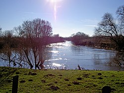
 The Leine near Sarstedt-Ruthe | |
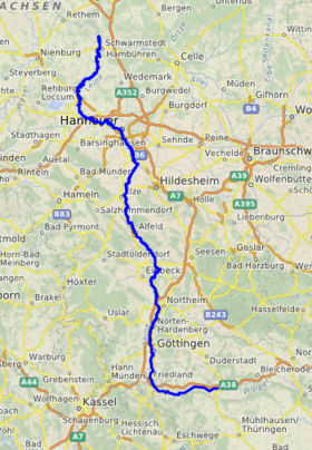
 Course of the Leine | |
| Country | Germany |
| States | Thuringia and Lower Saxony |
| Reference no. | DE: 488 |
| Physical characteristics | |
| പ്രധാന സ്രോതസ്സ് | In Leinefelde in the Eichsfeld ഫലകം:Höhe |
| നദീമുഖം | Near Schwarmstedt into the Aller at km 52.26[1] ഫലകം:Höhe 52°43′22″N 9°35′38″E / 52.72278°N 9.59389°E |
| നീളം | 281 കി.മീ (175 മൈ) |
| Discharge |
|
| Discharge (location 2) |
|
| Discharge (location 3) |
|
| Discharge (location 4) |
|
| നദീതട പ്രത്യേകതകൾ | |
| Progression | ഫലകം:RAller |
| നദീതട വിസ്തൃതി | 6,517 കി.m2 (7.015×10¹⁰ sq ft) [2] |
| Landmarks |
|
| പോഷകനദികൾ | |
 | |
ജർമ്മനിയിലെ തുരിംഗിയയിലും ലോവർ സാക്സോണിയിലുമുള്ള ഒരു നദിയാണ് ലീൻ (ജർമ്മൻ: [ˈlaɪnə] ⓘ; ഓൾഡ് സാക്സൺ ലാഗിന) . അലറിൻ്റെയും വെസറിൻ്റെയും ഇടത് കൈവഴിയായ ഇതിന് ഏകദേശം 281 കിലോമീറ്റർ (175 മൈൽ) നീളമുണ്ട്.
തുരിംഗിയയിലെ ലെയ്നഫെൽഡെ പട്ടണത്തിന് സമീപമാണ് നദിയുടെ ഉറവിടം. ഏകദേശം 40 കി.മീ (25 മൈൽ) നദിയുടെ താഴേക്ക്, നദി ലോവർ സാക്സോണിയിൽ പ്രവേശിച്ച് വടക്കോട്ട് ഒഴുകുന്നു. അതിൻ്റെ ഗതിയിലുള്ള പ്രധാന പട്ടണങ്ങൾ ഗോട്ടിംഗൻ, ഐൻബെക്ക്, ഫ്രെഡൻ, ആൽഫെൽഡ്, ഗ്രോനൗ എന്നിവയാണ്. ഹനോവറിന് വടക്ക് 40 കിലോമീറ്റർ (25 മൈൽ) താഴേയ്ക്ക്, ഷ്വാർംസ്റ്റെഡിന് സമീപം, നദി അലറുമായി ചേരുകയും വെസർ വഴി വടക്കൻ കടലിൽ എത്തുകയും ചെയ്യുന്നു.
അവലംബം
[തിരുത്തുക]- ↑ Längen (in km) der Hauptschifffahrtswege (Hauptstrecken und bestimmte Nebenstrecken) der Binnenwasserstraßen des Bundes, Wasser- und Schifffahrtsverwaltung des Bundes
- ↑ Environmental map service of Lower Saxony (Umweltkartendienst des Niedersächsischen Ministeriums für Umwelt, Energie und Klimaschutz)
