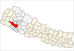
സുർഖേറ്റ് ജില്ല
ദൃശ്യരൂപം
Surkhet
सुर्खेत जिल्ला | |
|---|---|
 Location of Surkhet | |
| Country | Nepal |
| Region | {{{region}}} |
| വിസ്തീർണ്ണം | |
• ആകെ | 2,451 ച.കി.മീ. (946 ച മൈ) |
| ജനസംഖ്യ (2011) | |
• ആകെ | 3,50,804 |
| • ജനസാന്ദ്രത | 140/ച.കി.മീ. (370/ച മൈ) |
| സമയമേഖല | UTC+5:45 (NPT) |
| Main language(s) | Nepali |
| വെബ്സൈറ്റ് | www.ddcsurkhet.gov.np |
നേപ്പാളിലെ കർണലി പ്രവിശ്യയുടെ ഒരു ഭാഗമായ സുർഖേറ്റ് ജില്ല (Nepali: सुर्खेत जिल्ला, About this soundListen (help·info)) കർണാലിയിലെ 10 ജില്ലകളിൽ ഒന്നാണ്. തലസ്ഥാനമായ കാഠ്മണ്ഡുവിൽ നിന്ന് 600 കിലോമീറ്റർ (373 മൈൽ) പടിഞ്ഞാറ് സ്ഥിതി ചെയ്യുന്നു.[1]
References
[തിരുത്തുക]- ↑ "स्थानीय तहहरुको विवरण" [Details of the local level bodies]. www.mofald.gov.np/en (in Nepali). Ministry of Federal Affairs and Local Development. Retrieved 17 July 2018.
{{cite web}}: CS1 maint: unrecognized language (link)
- "Districts of Nepal". Statoids.


