അലക്സാണ്ട്രിയ വിർജീനിയ
ദൃശ്യരൂപം
അലക്സാണ്ട്രിയ, വിർജീനിയ | |||
|---|---|---|---|
| City of Alexandria | |||
 The George Washington Masonic National Memorial in 2015, with Washington, D.C. and Arlington in the distance | |||
| |||
| Coordinates: 38°48′17″N 77°02′50″W / 38.80472°N 77.04722°W | |||
| Country | United States | ||
| State | Virginia | ||
| County | Independent city | ||
| Founded | 1749 | ||
| Incorporated (town) | 1779 | ||
| Incorporated (city) | 1852 | ||
| Incorporated (Independent city) | 1870 | ||
| സർക്കാർ | |||
| • തരം | Council-manager | ||
| • Mayor | Allison Silberberg (D) | ||
| • Virginia Senate | Adam Ebbin (D) Richard L. Saslaw (D) George Barker (D) | ||
| • Delegate | Mark Levine (D) Charniele Herring (D) | ||
| • U.S. House | Don Beyer (D) | ||
| • U.S. Senate | Mark Warner (D) Tim Kaine (D) | ||
| വിസ്തീർണ്ണം | |||
• ആകെ | 15.5 ച മൈ (40.1 ച.കി.മീ.) | ||
| • ഭൂമി | 15.0 ച മൈ (38.9 ച.കി.മീ.) | ||
| • ജലം | 0.4 ച മൈ (1.1 ച.കി.മീ.) | ||
| ഉയരം | 39 അടി (12 മീ) | ||
| ജനസംഖ്യ (2010) | |||
• ആകെ | 1,39,966 | ||
• ഏകദേശം (2017) | 1,60,035 | ||
| • ജനസാന്ദ്രത | 10,660/ച മൈ (4,114/ച.കി.മീ.) | ||
| • Demonym | Alexandrian | ||
| സമയമേഖല | UTC-5 (EST) | ||
| • Summer (DST) | UTC-4 (EDT) | ||
| ZIP codes | 22301 to 22315, 22320 to 22336 | ||
| ഏരിയകോഡ്(കൾ) | 571, 703 | ||
| FIPS code | 51-01000[1] | ||
| GNIS feature ID | 1492456[2] | ||
| വെബ്സൈറ്റ് | www | ||
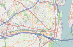
അലക്സാണ്ട്രിയ, അമേരിക്കൻ ഐക്യനാടുകളിലെ കോമൺവെൽത്ത് ഓഫ് വെർജീനിയയിലെ ഒരു സ്വതന്ത്ര നഗരമാണ്. 2010 ലെ അമേരിക്കൻ സെൻസസ് പ്രകാരം, ഈ നഗരത്തിലെ ആകെ ജനസംഖ്യ 139,966 ആയിരുന്നു. 2016 ൽ നഗര ജനസംഖ്യ 155,810 ആയി കണക്കാക്കിയിരുന്നു. പോട്ടോമാക്ക് നദിയുടെ പടിഞ്ഞാറൻ തീരത്ത് സ്ഥിതി ചെയ്യുന്ന അലക്സാണ്ട്രിയ നഗരം, വാഷിംഗ്ടൺ ഡി.സി. നഗരകേന്ദ്രത്തിൽനിന്ന് ഏകദേശം 7 മൈലുകൾ) (11 കിലോമീറ്റർ) അകലെയാണ് സ്ഥിതിചെയ്യുന്നത്.
അവലംബം
[തിരുത്തുക]- ↑ "American FactFinder". United States Census Bureau. Archived from the original on September 11, 2013. Retrieved January 31, 2008.
- ↑ "US Board on Geographic Names". United States Geological Survey. October 25, 2007. Retrieved January 31, 2008.

|
Arlington County | 
| ||
| Fairfax County | District of Columbia | |||
| Fairfax County |


