സെന്റ് ആൽബർട്ട്
ദൃശ്യരൂപം
(St. Albert, Alberta എന്ന താളിൽ നിന്നും തിരിച്ചുവിട്ടതു പ്രകാരം)
സെന്റ് ആൽബർട്ട് | |||
|---|---|---|---|
City | |||
| City of St. Albert | |||
 View of Downtown St. Albert | |||
| |||
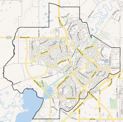
 City boundaries | |||
| ലുവ പിഴവ് ഘടകം:Location_map-ൽ 522 വരിയിൽ : Unable to find the specified location map definition: "Module:Location map/data/Edmonton" does not exist | |||
| Coordinates: 53°38′13″N 113°37′13″W / 53.63694°N 113.62028°W[1] | |||
| Country | Canada | ||
| Province | Alberta | ||
| Region | Edmonton Metropolitan Region | ||
| Adjacent municipal district | Sturgeon County | ||
| Founded | 1861 | ||
| Incorporated[2] | |||
| • Village | December 7, 1899 | ||
| • Town | September 1, 1904 | ||
| • New town | January 1, 1957 | ||
| • Town | July 3, 1962 | ||
| • City | January 1, 1977 | ||
| • Mayor | Cathy Heron | ||
| • Governing body |
| ||
| • CAO | William Fletcher | ||
| • MP | Michael Cooper (St. Albert—Edmonton-CPC) | ||
| • MLA | Marie Renaud (St. Albert-NDP) Dale Nally (Morinville-St. Albert-UCP) | ||
(2021)[4] | |||
| • ഭൂമി | 47.84 ച.കി.മീ.(18.47 ച മൈ) | ||
| ഉയരം | 689 മീ(2,260 അടി) | ||
(2021)[4] | |||
| • ആകെ | 68,232 | ||
| • ജനസാന്ദ്രത | 1,426.4/ച.കി.മീ.(3,694/ച മൈ) | ||
| • Municipal census (2018) | 66,082[6] | ||
| • Estimate (2020) | 69,335[7] | ||
| Demonym(s) | Stalbertite, Stan, Stanley | ||
| സമയമേഖല | UTC−7 (MST) | ||
| • Summer (DST) | UTC−6 (MDT) | ||
| Forward sortation area | |||
| ഏരിയ കോഡ് | 780, 587, 825, 368 | ||
| Highways | |||
| Waterways | Sturgeon River, Big Lake | ||
| വെബ്സൈറ്റ് | ഔദ്യോഗിക വെബ്സൈറ്റ് | ||
സെന്റ് ആൽബർട്ട് എഡ്മണ്ടൻ നഗരത്തിന്റെ വടക്കുപടിഞ്ഞാറായി, സ്റ്റർജിയൻ നദിക്കരയിലുള്ള ആൽബർട്ട പ്രവിശ്യയിലെ ഒരു നഗരമാണ്. യഥാർത്ഥത്തിൽ ഒരു മെറ്റിസ് സമൂഹം സ്ഥിരതാമസമാക്കിയിരുന്ന ഇത്, ഇപ്പോൾ എഡ്മന്റൺ മെട്രോപൊളിറ്റൻ മേഖലയിലെ രണ്ടാമത്തെ വലിയ നഗരമാണ്. 1904-ൽ സെന്റ് ആൽബർട്ടിന് ആദ്യമായി പട്ടണപദവി ലഭിക്കുകയും താമസിയാതെ 1906-ൽ കനേഡിയൻ നോർത്തേൺ റെയിൽപ്പാത അവിടെയെത്തുകയും ചെയ്തു.[8] യഥാർത്ഥത്തിൽ എഡ്മണ്ടൻ നഗരത്തിൽ നിന്ന് നിരവധി മൈലുകൾ വിസ്തൃതിയുള്ള കൃഷിയിടങ്ങളാൽ വേർപെടുത്തപ്പെട്ടിരുന്ന ഈ പട്ടണം, 1980-കളിലെ എഡ്മണ്ടൻ നഗരപരിധിയുടെ വിപുലീകരണത്തോടെ തെക്കും കിഴക്കും വശങ്ങളെ വലിയ നഗരമായ എഡ്മണ്ടനോട് തൊട്ടുകിടക്കുന്നതാക്കി മാറ്റി.
അവലംബം
[തിരുത്തുക]- ↑ "St. Albert". Geographical Names Data Base. Natural Resources Canada.
- ↑ "Location and History Profile: City of St. Albert" (PDF). Alberta Municipal Affairs. June 17, 2016. p. 113. Retrieved June 18, 2016.
- ↑ "Municipal Officials Search". Alberta Municipal Affairs. 2017-09-22. Retrieved 2017-09-25.
- ↑ 4.0 4.1 ഉദ്ധരിച്ചതിൽ പിഴവ്: അസാധുവായ
<ref>ടാഗ്;2021censusഎന്ന പേരിലെ അവലംബങ്ങൾക്ക് എഴുത്തൊന്നും നൽകിയിട്ടില്ല. - ↑ "Alberta Private Sewage Systems 2009 Standard of Practice Handbook: Appendix A.3 Alberta Design Data (A.3.A. Alberta Climate Design Data by Town)" (PDF) (PDF). Safety Codes Council. January 2012. pp. 212–215 (PDF pages 226–229). Archived from the original (PDF) on September 24, 2015. Retrieved October 9, 2013.
- ↑ ഉദ്ധരിച്ചതിൽ പിഴവ്: അസാധുവായ
<ref>ടാഗ്;2018MAPLഎന്ന പേരിലെ അവലംബങ്ങൾക്ക് എഴുത്തൊന്നും നൽകിയിട്ടില്ല. - ↑ "Census Subdivision (Municipal) Population Estimates, July 1, 2016 to 2020, Alberta". Alberta Municipal Affairs. March 23, 2021. Retrieved October 8, 2021.
- ↑ Edmonton Bulletin, September 27, 1906.

|
Barrhead | Morinville | Bon Accord | 
|
| Onoway | CFB Edmonton Fort Saskatchewan | |||
| Spruce Grove | Devon | Edmonton |
