ബെൽഗ്രേഡ്
ദൃശ്യരൂപം
Belgrade
Београд Beograd | |||
|---|---|---|---|
| City of Belgrade | |||
 Aerial view of Belgrade downtown and river shores | |||
| |||
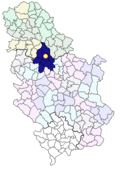
 Location of Belgrade within Serbia | |||
| Country | |||
| District | City of Belgrade | ||
| Municipalities | 17 | ||
| Founded | 269 B.C. | ||
| City rights | 150 A.D. | ||
| സർക്കാർ | |||
| • Mayor | Zoran Alimpić (DS) (acting) | ||
| • Ruling parties | DS/DSS/G17+ | ||
| വിസ്തീർണ്ണം | |||
• City | 3,222.68 ച.കി.മീ. (1,244.28 ച മൈ) | ||
| • നഗരപ്രദേശം | 1,035.0 ച.കി.മീ. (399.6 ച മൈ) | ||
| ഉയരം | 117 മീ (384 അടി) | ||
| ജനസംഖ്യ (2002.)[2] | |||
• City | 1.281.801 | ||
| • ജനസാന്ദ്രത | 7,450/ച.കി.മീ. (19,300/ച മൈ) | ||
| • നഗരപ്രദേശം | 1.780.801 | ||
| • നഗരജനസാന്ദ്രത | 4,880/ച.കി.മീ. (12,600/ച മൈ) | ||
| സമയമേഖല | UTC+1 (CET) | ||
| • Summer (DST) | UTC+2 (CEST) | ||
| Postal code | 11000 | ||
| ഏരിയ കോഡ് | (+381) 11 | ||
| Car plates | BG | ||
| വെബ്സൈറ്റ് | www.beograd.rs | ||
സെർബിയയുടെ തലസ്ഥാനവും, സെർബിയയിലെ ഏറ്റവും വലിയ നഗരവുമാണ് ബെൽഗ്രേഡ്. സെർബിയയിൽ സാവ,ഡാന്യൂബ് നദികളുടെ സംഗമതീരത്തായി സ്ഥിതി ചെയ്യുന്ന ഈ നഗരം ,പാനോനിയൻ സമതലത്തിന്റെയും, ബാൾക്കൻ ഉപദ്വീപിന്റെയും സംഗമഭൂമി കൂടിയാണ്. ഏതാണ്ട് 1.9 ദശലക്ഷം ജനസംഖ്യയുള്ള ഈ നഗരം മുന്നേ യൂഗോസ്ലാവ്യയിലെ ഏറ്റവും വലിയ നഗരവും ,തെക്ക് കിഴക്കൻ യൂറോപ്പിലെ ഇസ്താംബുൾ,ഏതൻസ്, ബുച്ചാറെസ്റ്റ് എന്നീ നഗരങ്ങൾക്കു ശേഷം നാലാമത്തെ വലിയ നഗരവുമാണ്.
- ബെൽഗ്രേഡ് is at coordinates 44°48′58″N 20°28′54″E / 44.8162°N 20.4816°E
അവലംബം
[തിരുത്തുക]- ↑ "Geographical Position". Official website of City of Belgrade. Retrieved 2007-07-10.
- ↑ Statistical Office of the Republic of Serbia (2008 estimate). Национална или етничка припадност - подаци по насељима (PDF) (in Serbian) (Књиге резултата Пописа 2002. ed.). Belgrade: Statistical Office of the Republic of Serbia. p. 14. Archived from the original (PDF) on 2006-11-02. Retrieved 2006-10-29.
{{cite book}}: Check date values in:|year=(help)CS1 maint: unrecognized language (link) CS1 maint: year (link)


