ക്യാറ്റ്മായ് ദേശീയോദ്യാനം
ദൃശ്യരൂപം
| Katmai National Park and Preserve | |
|---|---|
ഐ.യു.സി.എൻ. ഗണം VI (Managed Resource Protected Area) | |
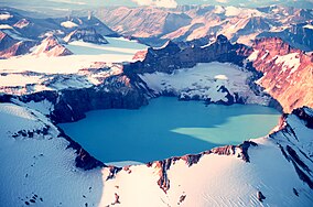
 The summit crater lake of Mount Katmai | |
| Location | Lake and Peninsula, Kodiak Island, Kenai Peninsula, and Bristol Bay boroughs, Alaska, USA |
| Nearest city | King Salmon |
| Coordinates | 58°30′N 155°00′W / 58.5°N 155°W |
| Area | 4,093,077 ഏക്കർ (16,564.09 കി.m2)[1] |
| Established | December 2, 1980 |
| Visitors | 37,818 (in 2016)[2] |
| Governing body | National Park Service |
| Website | Katmai National Park and Preserve |
അമേരിക്കൻ ഐക്യനാടുകളിലെ തെക്കൻ അലാസ്കയിൽ സ്ഥിതിചെയ്യുന്ന ഒരു ദേശീയോദ്യാനമാണ് ക്യാറ്റ്മായ് ദേശീയോദ്യാനം (ഇംഗ്ലീഷ്: Katmai National Park and Preserve). വാലി ഓഫ് ടെൻ തൗസന്റ് സ്മോക്സും, അലാസ്കൻ തവിട്ട് കരടികളുമാണ് ഈ ദേശീയോദ്യാനത്തിലെ ഒരു പ്രധാന സവിശേഷതകൾ. 4,093,077 ഏക്കർ (6,395.43 ച മൈ; 16,564.09 കി.m2), ആണ് ഉദ്യാനത്തിന്റെ ആകെ വിസ്തൃതി. 18ഓളം അഗ്നിപർവ്വതങ്ങൾ ഈ ദേശീയോദ്യാനത്തിന്റെ ഭാഗമാണ്, ഇതിൽ ഏഴെണ്ണം 1900 മുതൽക്കേ സജ്ജീവമായി നിലകൊള്ളുന്നു.
അവലംബം
[തിരുത്തുക]- ↑ "Listing of acreage as of December 31, 2011". Land Resource Division, National Park Service. Retrieved 2012-03-07.
- ↑ "Five Year Annual Recreation Visits Report". Public Use Statistic Office, National Park Service. Retrieved 2017-02-09.
കൂടുതൽ വായനക്ക്
[തിരുത്തുക]- Norris, Frank B. (1996) Isolated Paradise: An Administrative History of the Katmai and Aniakchak NPS Units, Alaska, National Park Service
പുറത്തേക്കുള്ള കണ്ണികൾ
[തിരുത്തുക]Katmai National Park എന്ന വിഷയവുമായി ബന്ധപ്പെട്ട ചിത്രങ്ങൾ വിക്കിമീഡിയ കോമൺസിലുണ്ട്.
![]() വിക്കിവൊയേജിൽ നിന്നുള്ള ക്യാറ്റ്മായ് ദേശീയോദ്യാനം യാത്രാ സഹായി
വിക്കിവൊയേജിൽ നിന്നുള്ള ക്യാറ്റ്മായ് ദേശീയോദ്യാനം യാത്രാ സഹായി
- Katmai National Park and Preserve National Park Service site
- Katmai National Park and Preserve at the National Park Service Alaska Regional Office
- Katmai: Alaska's Wild Peninsula[പ്രവർത്തിക്കാത്ത കണ്ണി] A film by John Grabowska.

